Montenegro Road Trip Itinerary: The Best Self-Drive Route
A 6-7 day Montenegro road trip from coast to mountains: Kotor, Sveti Stefan, Skadar Lake, the Tara Bridge and Durmitor - stops, distances and tips.
Montenegro is one of the great small road-trip countries: in a week you can drive from a walled medieval port on the Adriatic up into glacial mountains over 2,000 m high, by way of a royal capital, the largest lake in the Balkans and the deepest river canyon in Europe - all in a country smaller than Wales. This itinerary strings the headline sights into a single six-to-seven-day loop of roughly 450 km, starting and finishing on the coast, with a hire car doing the work. The distances are modest; the time goes on the mountain roads, the swimming and the views, not on motorway miles.
The plan runs Kotor → Sveti Stefan (via Budva) → Podgorica → Lake Skadar → the Tara Bridge → Durmitor, then back to the coast. You can tighten it into five hard-driving days or stretch it past ten with beach and hiking time. Either way it pairs the Boka Kotorska coast with the wild north around Žabljak, so you see both halves of the country rather than just the seaside. For how the individual pieces connect - buses, the Kamenari ferry, tolls and taxis - see our guide to getting around Montenegro.
How long do you need: 5, 7 or 10 days?
Five days is the quick version: two on the bay, then a fast push north to Durmitor and back. Seven days - the sweet spot this itinerary is built around - adds proper time at Lake Skadar and a full day in the mountains without driving yourself ragged. Ten days lets you fold in extra coast (Perast, the beaches south of Budva), a rafting trip on the Tara, or a night in Kolašin on the way back.
| Pace | What you fit in | Where you sleep |
|---|---|---|
| 5 days | Kotor, Budva/Sveti Stefan, Tara Bridge, Durmitor (flying visit) | Kotor + Žabljak |
| 7 days | + Podgorica, Lake Skadar, a full Durmitor day | Kotor + Žabljak + 1 |
| 10 days | + Perast, beaches, Tara rafting, Kolašin | Spread across the loop |
The mileage, days and budget on the summary card are a guideline, not an exact measurement - they shift with how many detours you take, the season and where you stay. The budget from €70 figure is a rough daily floor per person in shoulder season (a modest room, a shared hire car, simple meals and the odd park fee); high summer on the coast runs well above it.
Day 1-3: Kotor and the Bay of Kotor
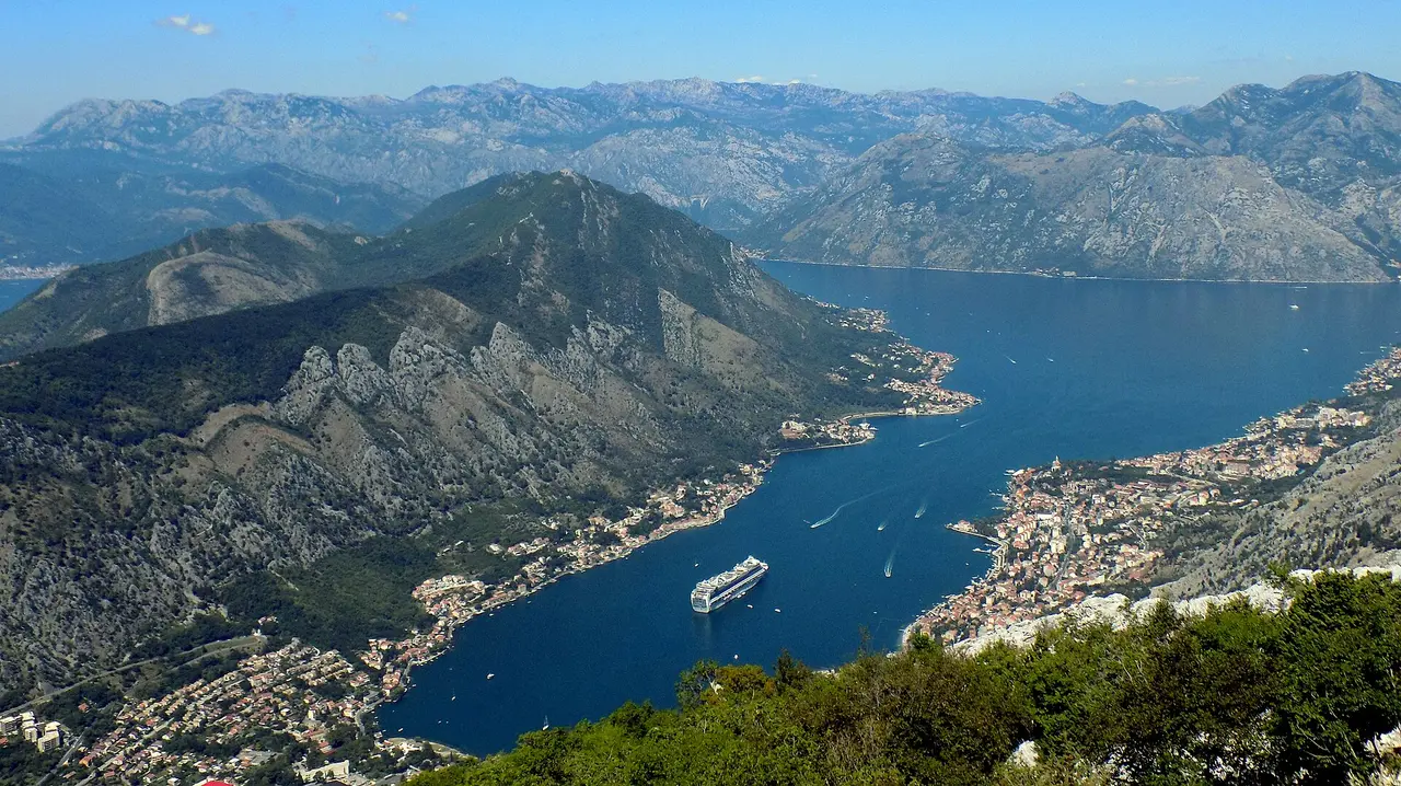
Start in Kotor, tucked at the very back of the bay where the cliffs crowd in steepest. The walled old town is a UNESCO World Heritage Site and entirely car-free, so leave the car outside and walk in through the Sea Gate. The big effort is the climb up the city walls to the Fortress of San Giovanni on the ridge - roughly 1,350 steps and a sweeping view over the rooftops and the fjord-like bay; go early or near sunset to beat the heat and the cruise crowds. Full details are in our Kotor guide.
Give the bay two or three nights. From Kotor it is a short hop up the shore to Perast, a Baroque town of stone palazzi with shuttle boats out to the island church of Our Lady of the Rocks, and the Kamenari-Lepetane ferry cuts across the narrows if you want to loop the bay quickly. This stretch overlaps with our dedicated Bay of Kotor coast itinerary, which is worth reading if you want to slow right down on the coast before heading inland. If you would rather follow the shore the whole way south instead of cutting inland here, the Montenegro coastal road trip runs from Herceg Novi past Budva all the way to Ulcinj.
Day 3-4: Budva, Sveti Stefan and the coast south
Drive south along the coast road to Budva, the liveliest resort on the Montenegrin shore: a compact Venetian old town on a little peninsula, a citadel and a run of beaches, plus the busiest nightlife in the country. It makes an easy lunch-and-swim stop or a second base - see our Budva guide for the old town and beaches.
Just south is Sveti Stefan, the fortified islet that appears on every Montenegro postcard - a former fishing village turned exclusive resort, joined to the mainland by a slim causeway. The island itself is private and usually closed to non-guests, but the classic shot is free from the viewpoint on the main road above, and the beaches either side of the causeway are open. It is a short stop: half an hour for the photo, longer if you swim.
Day 4-5: Podgorica and Lake Skadar
Turn inland for Podgorica, the capital - a green, low-rise city on the Morača river that most travellers use as a hinge rather than a destination. Stretch your legs around the Millennium Bridge, the old Stara Varoš quarter with its Ottoman clock tower, and a riverside café before carrying on. Our Podgorica travel guide has the worthwhile stops if you stay the night.
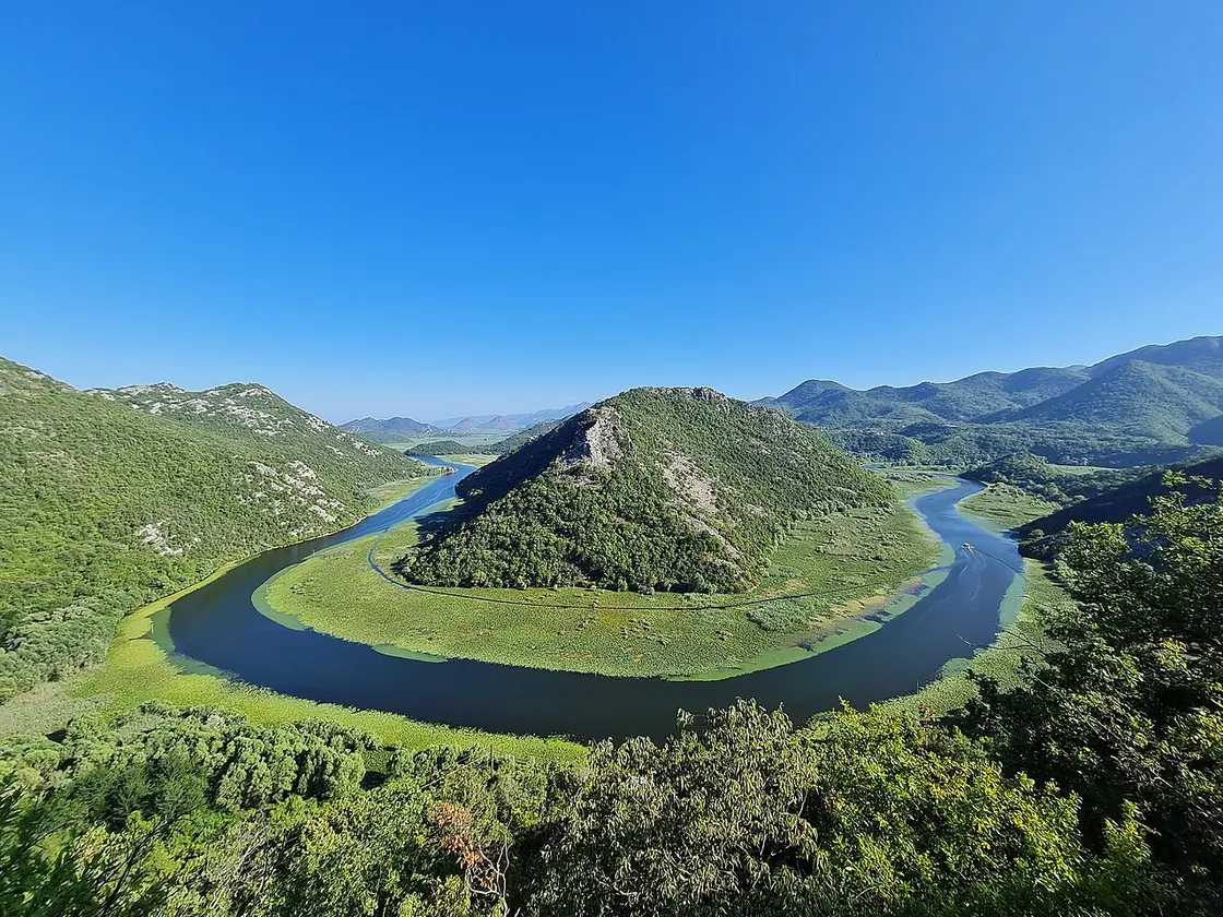
A short detour from the Podgorica-coast road reaches the signature view of Skadar Lake National Park: the Pavlova Strana viewpoint above Rijeka Crnojevića, where the river coils into a flawless green horseshoe below limestone hills. Skadar is the largest lake in the Balkans, a wetland full of birds, monasteries and tiny villages; boat trips run from the water’s edge. More on the lake - its viewpoints, wineries and boat tours - in our Lake Skadar guide.
Day 5-6: north to the Tara Bridge
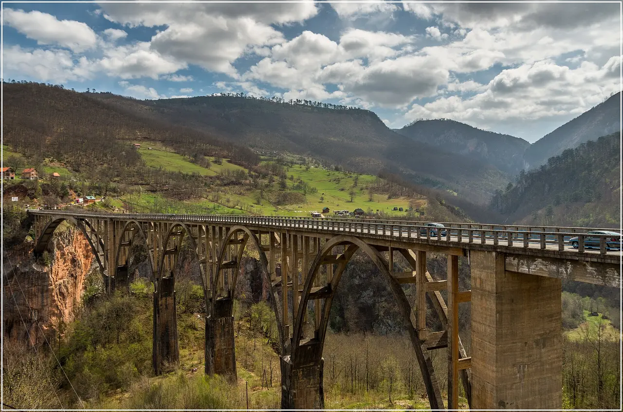
Now the long, scenic haul north. The road climbs out of the Podgorica basin through Kolašin and over high passes into the Tara country - the single best stretch of driving on the trip, and slow going, so allow most of a day and break it where you fancy. The landmark is the Đurđevića Tara Bridge, a graceful concrete arch finished in 1940 that leaps the Tara canyon - at over 1,300 m deep, the deepest in Europe and second only to the Grand Canyon worldwide. Pull in at either end for the view down to the green river far below.
Around the bridge the canyon has become Montenegro’s adventure hub: zip-lines span the gorge, and the Tara is the country’s premier rafting river, with half-day and full-day trips run by local operators in season. If you have the time and the nerve, it is the most memorable detour on the route.
Day 6-7: Durmitor National Park
The trip ends high. Just west of the bridge lies Durmitor National Park, a UNESCO-listed massif of limestone peaks, glacial lakes and the highland town of Žabljak - at around 1,450 m, the highest town in the Balkans and your base up here. The set-piece is the Black Lake (Crno jezero), a pair of joined glacial lakes a short walk from town, ringed by pine forest and reflecting the bulk of Meded and Savin Kuk. The easy loop around the shore takes an hour or two and is doable for almost anyone; serious walkers can push on to the higher lakes and peaks.
Spend a full day here - a lake walk, a drive on the Durmitor Ring road past viewpoints and shepherds’ huts, and the clean mountain air that feels a world away from the coast you started on. Then it is back south to Kotor or on to your departure airport. For the practical side of the whole loop - fuel, tolls, the ferry and parking - read getting around Montenegro before you set off.
Driving the route: roads, seasons and the car
This is a rewarding but demanding self-drive. A few things make it go smoothly:
- Take a small or mid-size car. The coastal serpentines and the mountain roads north are narrow, steep and twisty, often with passing places rather than two clear lanes. A compact car is easier everywhere and cheaper to hire and fuel. Our guide to renting a car in Montenegro covers pickup points, the green card for border trips and how to keep costs down.
- Allow more time than the map says. Average speeds in the mountains are low, and summer traffic on the coast road backs up badly around Kotor and Budva. Don’t plan to cover the whole north in a single morning.
- Tolls and fuel. The Sozina tunnel (Podgorica-Bar) and the newer Bar-Boljare motorway section both carry a small toll; otherwise the roads are toll-free. Carry some euro coins for parking machines and rural fuel stations, which don’t all take cards.
- When to go. Late spring to early autumn (May-October) is the window: the coast is warm and the high passes and Durmitor roads are clear of snow. In winter the mountain section can close or need winter tyres and chains, and Žabljak turns into a small ski town. Our best time to visit Montenegro guide has the month-by-month picture.
Montenegro uses the euro (€), even though it is not in the EU; cards work in towns, but carry cash for park fees, parking, boat trips and small cafés. To see how this loop fits a longer trip, see the Montenegro travel guide, and browse more ready-made routes for other ideas.
Nearby / read also
- Getting around Montenegro - buses, taxis, ferries and the practical side.
- Bay of Kotor coast itinerary - a slower loop of the bay and the coast.
- Renting a car in Montenegro - pickup points, roads and costs.
- Kotor guide · Budva guide · Lake Skadar guide · Durmitor National Park
- All routes in Montenegro - more driving ideas.
Route day by day
- Days on the road
- 7
- Distance
- ≈450 km
- Budget from
- 70 EUR
- Best season
- May, June, July, August, September, October
-
Kotor
Route startstop ≈600 min
Start in the walled UNESCO old town at the head of the Bay of Kotor. Climb the city walls to the San Giovanni fortress, then base here for the first nights and explore Perast and the bay.
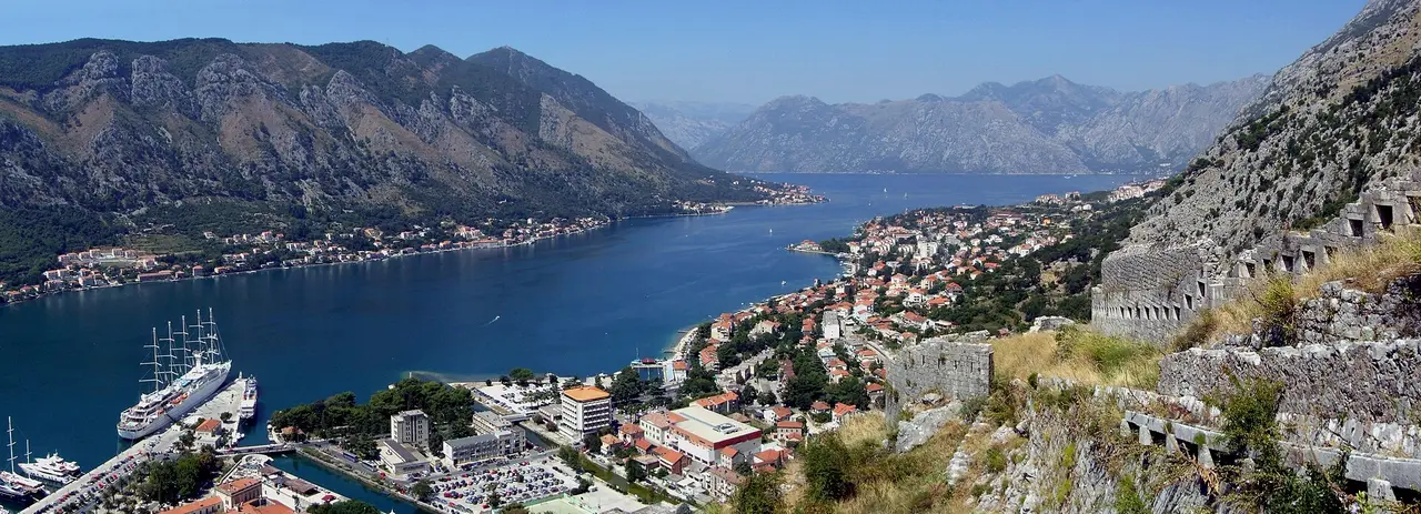
Photo: Pudelek (Marcin Szala) / Wikimedia Commons, CC BY-SA 3.0 -
Sveti Stefan
45 km from the startstop ≈180 min
South past Budva to the most photographed view on the coast: the fortified islet of Sveti Stefan on its causeway. The island is a private resort, but the viewpoint above the road is free, and Budva’s old town and beaches are minutes away.
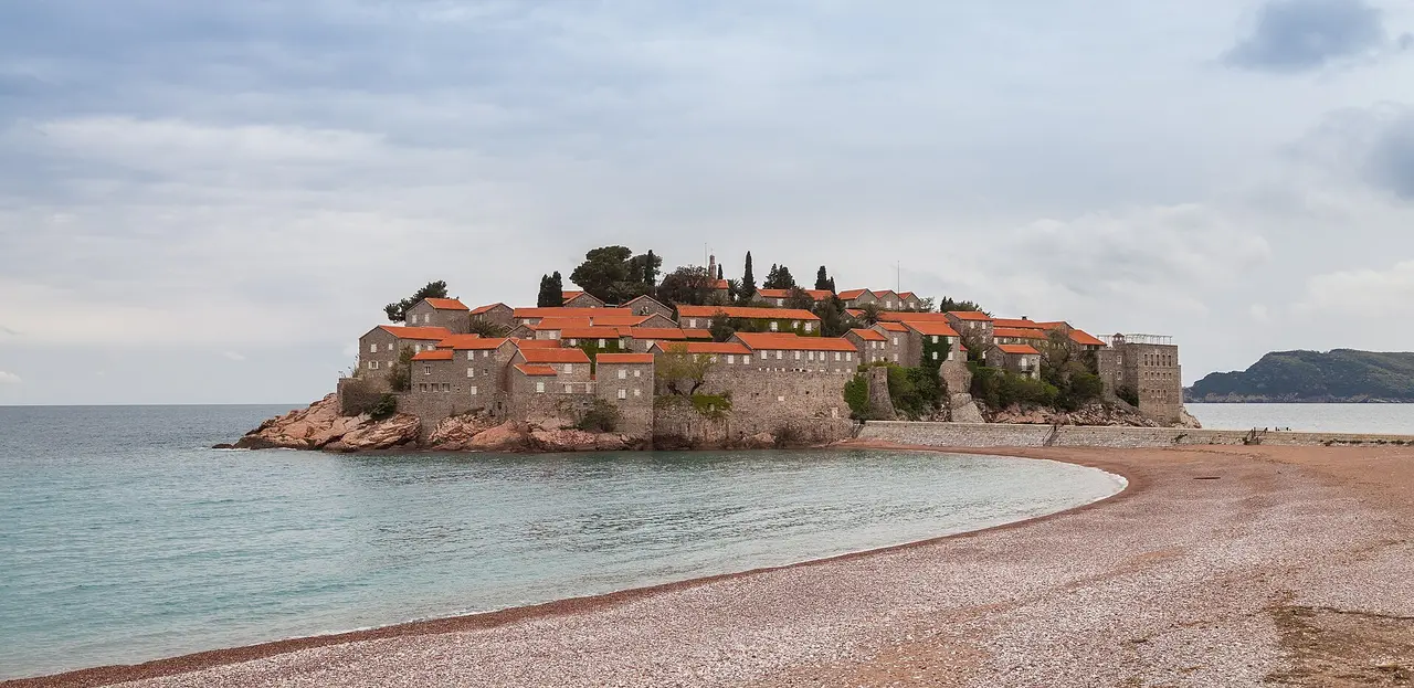
Photo: Diego Delso / Wikimedia Commons, CC BY-SA 4.0 -
Podgorica
110 km from the startstop ≈180 min
Cut inland to the capital - a low-key, leafy city on the Morača river, useful as a hinge between the coast and the mountains. See the Millennium Bridge, the old Stara Varoš quarter and the clock tower before pushing north.
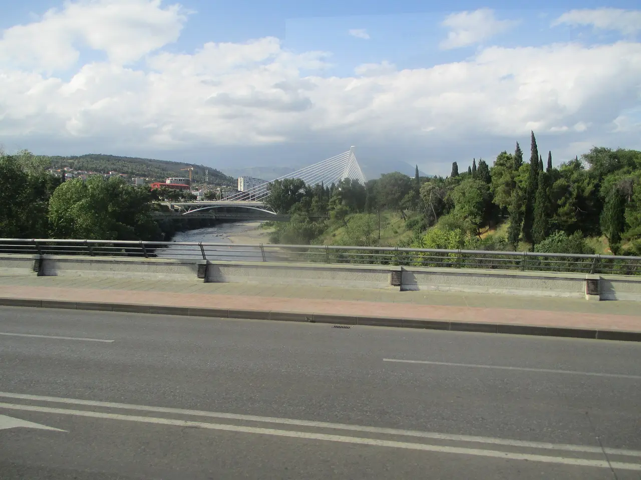
Photo: Avi1111 dr. avishai teicher / Wikimedia Commons, CC BY-SA 4.0 -
Lake Skadar (Rijeka Crnojevića)
145 km from the startstop ≈150 min
A short detour to the Pavlova Strana viewpoint above Rijeka Crnojevića, where the river loops into a perfect green horseshoe - the signature image of Skadar Lake National Park, the largest lake in the Balkans.
Photo: A81t / Wikimedia Commons, CC BY-SA 4.0 - sourceUrl: https://commons.wikimedia.org/wiki/File:Pavlova_Strana,_Rijeka_Crnojevi%C4%87a,_Cetinje.jpg -
Đurđevića Tara Bridge
320 km from the startstop ≈90 min
The long drive north climbs into the high country to the Đurđevića Tara Bridge - a graceful 1940s concrete arch spanning the Tara canyon, Europe’s deepest. A classic photo stop, with zip-lines and rafting put-ins nearby.
Photo: Arno Hoyer / Wikimedia Commons, CC BY 2.0 -
Durmitor & the Black Lake
345 km from the startstop ≈480 min
Finish in Durmitor National Park around Žabljak, Montenegro’s highest town. The easy walk around the glacial Black Lake (Crno jezero), under the Meded and Savin Kuk peaks, is the set-piece - base here for a day before the run back to the coast.
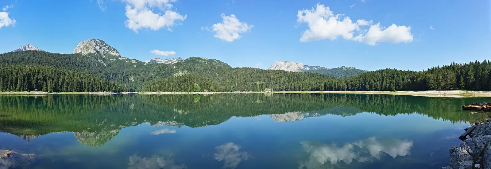
Photo: Ingo Mehling / Wikimedia Commons, CC BY-SA 4.0
Route map
The map with stops loads on click - to keep the page lightweight.
The map didn’t load. Check your connection and refresh the page.