Durmitor National Park: lakes, peaks & Tara Canyon
Durmitor National Park in northern Montenegro: the Black Lake, Bobotov Kuk, the Tara Canyon and how to plan your visit from Podgorica.
Durmitor National Park is the high-mountain heart of northern Montenegro: a UNESCO World Heritage massif of glacial lakes, sharp limestone peaks and the deepest river canyon in Europe. Most visitors base themselves in the small town of Žabljak, walk the easy loop around the Black Lake, photograph the Tara Canyon from the Đurđevića Tara Bridge, and — if they have the legs for it — climb to a summit or two. It is roughly a 2.5–3 hour drive from Podgorica, and the best window for hiking runs from June to September.
Why Durmitor is worth the drive
Durmitor sits on a limestone plateau in Montenegro’s mountainous north, and it earned its UNESCO World Heritage status for exactly the landscape you come to see: a compact range scoured by Ice Age glaciers, dotted with lakes and split by gorges. The park combines several “wow” features in one place — eighteen glacial lakes (locals call them gorske oči, the “mountain eyes”), peaks rising past 2,500 m, and the Tara River carving the deepest canyon on the continent.
What makes it practical as well as beautiful is the gateway town. Žabljak sits at around 1,450 m, which makes it one of the highest towns in the Balkans, and it is the obvious base: the Black Lake trailhead is on its doorstep, and rafting trips, viewpoints and longer hikes all radiate out from here. You can taste the park in a single day trip, but two or three nights let you slow down and actually walk it.
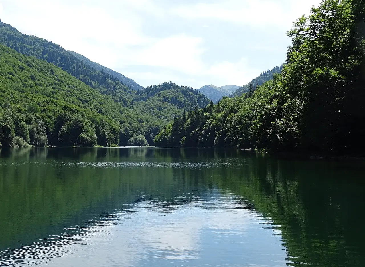
The Black Lake (Crno jezero)
If you do only one thing in Durmitor, make it the Black Lake. This glacial lake is the park’s icon — dark, still water ringed by spruce forest with the peaks reflected on a calm morning. It sits a short distance from Žabljak, and an easy walking loop of roughly 3.5 km circles the shoreline, mostly flat and well-trodden, suitable for families and anyone wanting a gentle introduction to the massif.
The lake is really two basins joined by a narrow neck; in high summer the water level drops and you can sometimes walk between them. Come early or late in the day for the best light and the fewest people — midday in July and August is the busiest the park gets. Bring water and proper shoes even for the loop, since the path has roots and stones.
The Black Lake is also the natural starting point for going deeper. Several of the park’s other lakes and trails branch off from here, so even if you only plan the loop, you will see signposts tempting you toward the high country.
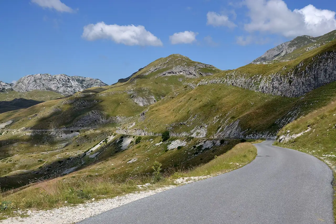
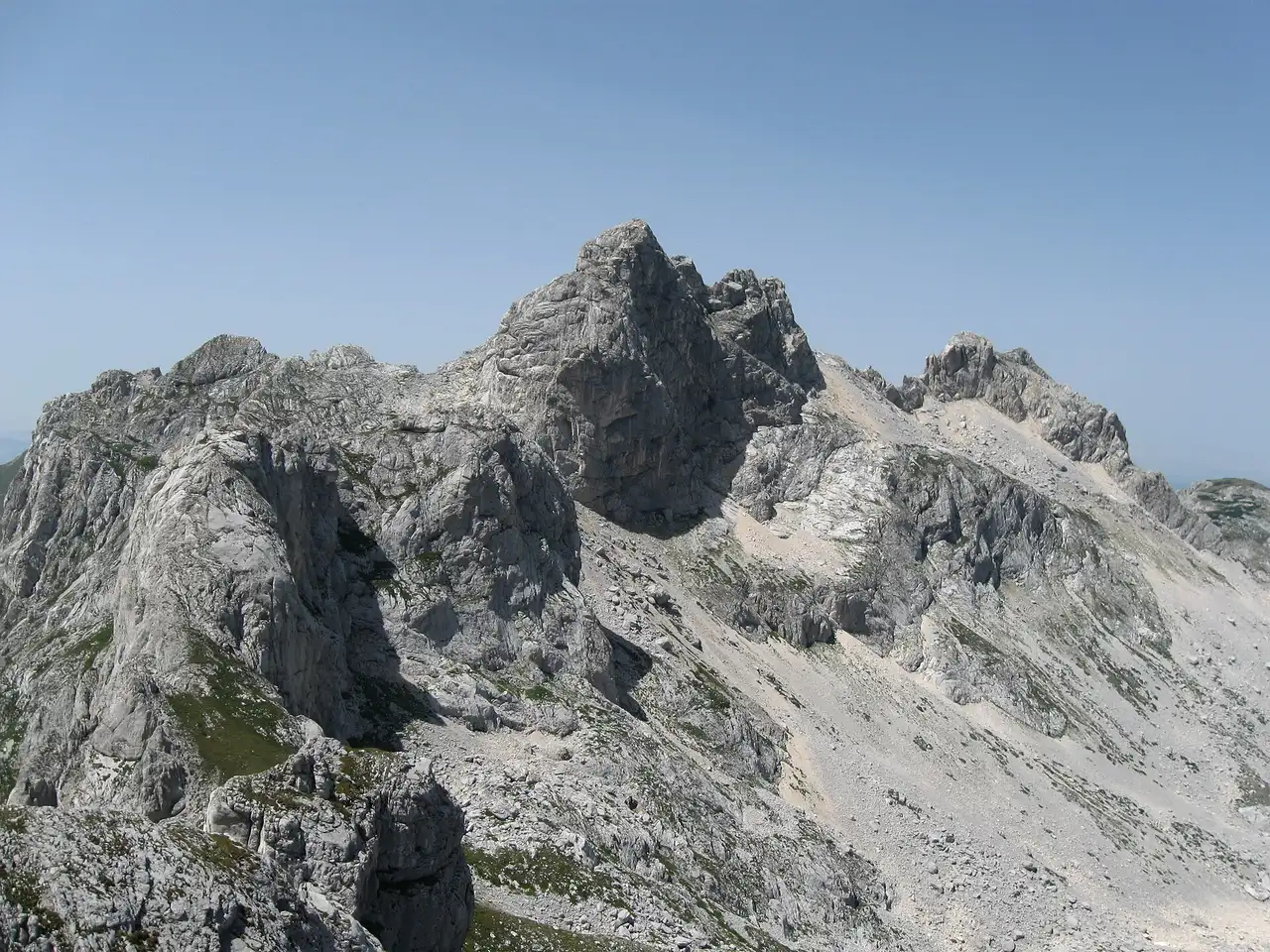
Bobotov Kuk and hiking the high peaks
Durmitor is serious hiking territory. The headline summit is Bobotov Kuk at 2,523 m, the highest peak in the massif and a demanding full-day hike that should not be underestimated — it involves a long approach, steep ground and exposure near the top, and it is firmly for fit, experienced walkers with good weather and an early start. It is not a casual stroll, and the mountain weather can turn fast.
You do not have to summit Bobotov Kuk to enjoy the high terrain, though. The massif is laced with marked trails of every length, linking the glacial lakes, ridges and viewpoints. Plan around the season: the high routes are best from June to September, when most of the snow has cleared and the days are long. Outside that window, paths can hold snow well into early summer and weather closes in early in autumn. Whatever you choose, carry layers, water and a map, and check the forecast — see our best time to visit Montenegro guide for how the mountain seasons differ from the coast.
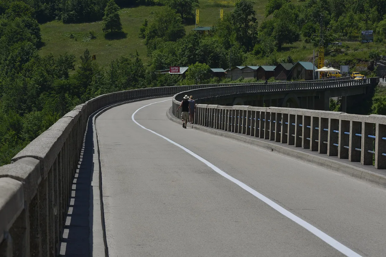
The Tara Canyon and rafting
A short drive from Žabljak takes you to the park’s other signature sight: the Tara River Canyon, the deepest canyon in Europe at around 1,300 m. It is crossed by the elegant Đurđevića Tara Bridge, an arched concrete span that is a destination in its own right — the view down into the gorge from the bridge is one of the most photographed scenes in Montenegro, and there are zip-lines and viewpoints clustered around it.
The classic active experience here is Tara rafting. Trips run on the river’s emerald water roughly from May to October, with the volume and excitement highest in spring snowmelt and gentler later in the season. Operators offer everything from short half-day floats to longer descents, and most include the gear and a guide. If you are visiting in summer and want one adventure to remember, this is it.
| Highlight | What it is | Effort | Best months |
|---|---|---|---|
| Black Lake loop | Easy ~3.5 km lakeshore walk | Easy | Jun–Sep (open most of year) |
| Bobotov Kuk | Highest peak, 2,523 m | Hard, full day | Jun–Sep |
| Tara rafting | River trip through Europe’s deepest canyon | Moderate | May–Oct |
| Đurđevića Tara Bridge | Iconic canyon viewpoint | Easy | Year-round |
Getting there and getting around
Durmitor is in the north, so it takes a little effort to reach — that remoteness is part of why it stays wild. From Podgorica it is roughly 140 km and about 2.5–3 hours by car, on mountain roads that are scenic but slow, so leave a margin and avoid driving the highest sections after dark. From the coast (Kotor, Budva) it is a longer half-day haul.
A car is by far the most flexible way to explore: the trailheads, the bridge and the rafting launch points are spread out, and public transport between them is limited. If you are planning a wider Montenegro trip, see our notes on renting a car in Montenegro. Prefer to skip the driving? Organised day trips and guided rafting and hiking tours run from the coast and from Žabljak — a good option if your time is short or you would rather leave the mountain roads to someone else.
Activities shift with the calendar. Summer (roughly June–September) is for hiking, lake walks and rafting; winter turns Žabljak into a modest ski area, with snow on the plateau and slopes nearby. Spring and autumn are quieter and beautiful but can be wet and cold at altitude. For where Durmitor fits in a broader itinerary, our Montenegro travel guide maps the country region by region.
Nearby / read also
On the map
The map loads on click — to keep the page lightweight.
The map didn’t load. Check your connection and refresh the page.
Distance≈140 km · ≈2.5–3 ч
- Podgorica≈140 km · ≈2.5–3 ч
Read also
Lake Skadar National Park: boats, birds & wine
Updated · June 23, 2026Lake Skadar is the largest lake in the Balkans and a national park of pelicans, boat trips and Crmnica wine. What to see and how to visit from Podgorica.
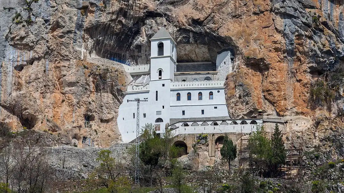
Ostrog Monastery: How to Visit Montenegro's Cliff Shrine
Updated · June 22, 2026Ostrog Monastery clings to a cliff above the Bjelopavlići plain. How to visit: dress code, hours, the upper and lower monasteries and getting there.

Flynas Resumes Riyadh–Podgorica Flights for Summer 2026
Updated · June 24, 2026Flynas reopens its seasonal Riyadh–Podgorica route from 25 June 2026: three flights a week on an A320, a direct link from Saudi Arabia to Montenegro.
Made in NY Jazz Festival: Free Night in Tivat, 26 June
Updated · June 24, 2026The 11th Made in New York Jazz Festival hits Porto Montenegro in Tivat on 26 June 2026 — free entry, John Scofield Trio and Frank McComb on the bill.